FAQ
PLAN DOCUMENT – FAQ
A comprehensive plan is a policy document that details the City’s long-term vision and goals and outlines the steps necessary to achieve them. The Plan is intended to guide growth and development in an organized, equitable, and sustainable manner. To do so, it looks to the future to anticipate trends and issues that could impact how growth and development occur and addresses topics like land use, housing, transportation, economic development, and more. The plan is long range (20 years) in scope, focusing on the ultimate needs of the community based on conversations with thousands Charlotteans and our Equitable Growth Framework , among other items. It will be used to inform ordinances like the Unified Development Ordinance, inform housing decisions, and shape land development decisions and future community investment plans.
Charlotte is expected to add 385,000 new residents and 212,000 new jobs, creating a city of over 1 million people by 2040. The plan lays out the policies for how Charlotteans want their city to grow. Having a vision for growth is critical to the long-term success of our city. It is the guiding document that City agencies, residents, employers, developers, and other stakeholders use to ensure that we retain a high quality of life for our residents.
The 2040 Comprehensive Plan is founded on an Equitable Growth Framework. This Framework is informed and shaped by the community based on the assumption that we must listen to each other and consider the intended and unintended consequences of growth on all residents, households, and neighborhoods. It identifies and measures areas in Charlotte where residents and businesses may not have access to daily needs, choices for housing, a diversity of employment, or safe and healthy environments while providing more transparency and accountability as we plan, design, and implement public and private investments in housing, employment, services, schools, parks, roads, trails and other infrastructure.
Our process includes addressing the planning practices of the past that resulted in policies, programs, and regulations that disproportionately impacted the progress of certain segments of Charlotte’s population more than others, especially people of color. The Equitable Growth Framework and the 2040 Comprehensive Plan cannot reverse the wrongs of two and a half centuries, but they can acknowledge those injustices and set a clear direction for change, establish goals for more equitable growth, and provide a lens through which to evaluate a deliberate and concerted effort to make a more inclusive and equitable Charlotte.
The Equitable Growth Framework represents a commitment to thinking of our most vulnerable populations first with a vision of helping our city become a place where all residents can thrive, regardless of race, income, age, ability or where they live.
The Adopted Plan is the result of a two-year effort to meet with people and have conversations across the city, integrating thousands of comments collected during the community engagement process. Meaningful and robust conversations have been held with over 7,500+ voices from the community, including 480+ key stakeholders.
Over 40 methods of engagement have been used totaling 500,000+ interactions. Activities have included community workshops, pop-up meetings, a guest-speaker/lecture series, podcasts, radio and TV interviews, surveys, a board game, a card game, street festivals, webinars, online workshops, emails, and social media, all of which include both English and Spanish-language content.
The 2040 Comprehensive Plan team values all the comments that were received on the draft plan during the review period from October 2020 – June 2021.
Over 1000 comments were received via email, online, phone, and mail from the community, elected and officials, and staff. These comments are available to view online at www.cltfuture2040plan.com in the top menu.
Once the comment period closed, Staff and Planning Commission collaborated to recommend plan revisions to Council’s Transportation, Planning & Environment Committee and then to full City Council.
On June 21, 2021 City Council adopted the Plan Policy with the directive to adopt the Implementation Strategy and the Manuals and Metrics (including the Charlotte Future 2040 Policy Map) by February/March 2022.
The Charlotte Future 2040 Comprehensive Plan includes 10 goals that are based on four guiding principles and five vision elements.
Guiding Principles
The plan is based around four guiding principles used to establish a decision-making framework throughout the life of the Plan based on robust and meaningful conversations with over 5,500 voices from the community.
Vision Elements
Five vision elements describe how Charlotteans picture their city in the future which are the lens through which the Plan’s goals and objectives were created and analyzed.
Goals
The 2040 Comprehensive Plan’s Policy Framework builds upon the guiding principles, vision elements and community values, providing actionable responses to the Equitable Growth Framework’s priorities of improving access, distributing the costs and benefits of growth, and creating asset-based and culturally rich places. It also creates new policies that, when adopted by City Council, will require partnerships and collaboration across departments, organizations, public, private and non-profit sectors, as well as the broader community.
The project team is coordinating the Charlotte Future 2040 Plan with other plans and policies being developed (e.g.: Charlotte Moves, Unified Development Ordinance, 2050 Metropolitan Transportation Plan, etc.). Policies identified in the 2040 Plan will be used to inform and shape policies in other plans that affect Charlotte.
This is not a plan that will just sit on a shelf. Each of the 10 Goals introduced in the Equitable Growth Framework defines success through a set of objectives, highlights more significant changes through big ideas, articulates a diverse set of policies, and includes projects and programs to help make the vision a reality. The plan also includes an implementation strategy and discusses next steps for community area mapping, both of which are critical components to implementing the Unified Development Ordinance (UDO).
The strategy focuses on the initial five years of after adoption of the 2040 Comprehensive Plan and includes recommendations for short-term actions to implement the Plan’s policies, projects and programs; a revised approach to coordinating and aligning planning in Charlotte; highlights of the update to the Unified Development Ordinance (UDO); findings from a Fiscal Impact Analysis; funding and financing tools; a suggested approach to identifying and prioritizing public projects; organizational considerations; and a road map for tracking progress moving forward.
Charlotte Future 2040 Policy Map
This effort will translate the policies passed in the comprehensive plan into a policy map which will be used in multiple decision-making processes.
The Charlotte Future 2040 mapping process will be completed using a new tool, Place Types, and will follow a 3-step process.
The Unified Development Ordinance (UDO)
The UDO will be the primary tool to implement the 2040 Comprehensive Plan policies through development regulations. It will combine multiple development ordinances, including the Zoning Ordinance, into one set of regulations. These regulations will help shape future development so that it results in the type of complete communities and places defined by the Charlotte Future 2040 Comprehensive Plan goals and policies.
The UDO is also instrumental in implementing other City policies that will nest under the Comprehensive Plan’s overarching guidance such as Charlotte Moves, the Urban Street Design Guidelines, the Strategic Energy Action Plan, the Urban Forestry Master Plan, and the Tree Canopy Action Plan.
No, the 2040 Comprehensive Plan does not call for the end of single family homes. The plan does, however, include policies which support and encourage a wider variety of housing types in more places within the community.
No. According to North Carolina General Statues Chapter 40A, eminent domain may only be used for a “public use or benefit.” Public use or benefit is defined as being for transportation investments, utilities, parks, public buildings (e.g.: fire stations, police stations, etc.), etc. (§ 40A-3 (b)).
Charlotte is one of the fastest growing cities in the nation with over 385,000 people and 212,000 jobs projected to be added to the city over the next two decades, creating a city with over 1 million people. With this growth comes increased demand for housing and an associated increase in housing costs and rents. As a result, housing units that were once affordable no longer are, and less housing is available for low-income residents of Charlotte.
The 2040 Comprehensive plan calls for allowing more housing options, especially in areas that lack housing choices and access to transit, jobs and goods and services. The proposed policies also call for creating and expanding resources to produce and preserve affordable housing and minimizing the displacement of residents and creating affordable transportation options to improve access to jobs.
UNC Charlotte’s State of Housing in Charlotte Report (October 2020), states that the supply of housing in Charlotte is extremely low, and as a result, the market is extremely competitive and driving up prices. It also reports that the number of days on the market for for-sale units in October 2020 was 10 days versus 90 days in 2010. Prior to 2010, the number of days on the market was never been below 30 days. Additionally, rising land prices, decreasing supply, and increasing household formations result in increased demand, further exacerbating housing prices. More housing supply across all price points is needed in Charlotte.
By offering a wider range of housing choices, our residents and stay and age in place. For example, if an older adult wants to downsize and has lived in a single-family home for years and they have their grocery store, their dentist, their doctors, and their grandkids all close by. This policy allows them to have the option of moving into something smaller and more manageable, like a townhome or duplex but in the same neighborhood. A mix of housing options and lot sizes can increase residential density and help create an even more vibrant community. Many examples of these housing options already exist in many of our neighborhoods today.
According to North Carolina law, the City cannot require developers to build affordable housing and prohibits municipalities from regulating design aspects of one- and two-family dwellings. The City is considering ways in the 2040 Comprehensive Plan to incentivize developers to include affordable units and will further evaluate additional incentives in the Unified Development Ordinance (UDO).
The City currently has several initiatives around affordable housing and protecting neighborhoods. The 2040 Comprehensive Plan aims to build on those with additional programs and tools to increase home ownership, promote aging in place, create neighborhood character overlays, and other programs.
This topic has been referred to the Great Neighborhoods Committee by the Mayor for further discussion, and additional discussion will occur in Council Committees and town halls.
- There are many cities and states that have adopted this approach as a way to increase the availability of housing in their communities.
- The North Carolina House and Senate each have bills on the floor to require municipalities to include attached housing in all residential areas.
- We will likely see incremental change in Charlotte in terms of housing diversity. Many lots in Charlotte have deed restrictions that allow only single-family structures, and many may have lot dimensions that would challenge the feasibility of constructing attached dwellings.
- Additional housing is needed in Charlotte and as well as an opportunity to have different types of housing in our neighborhoods to fit different types of households.
- The 2040 Comprehensive Plan policies support the preservation and enhancement of the city’s tree canopy. In addition to the 2040 Plan, the City is developing the Tree Canopy Action Plan. This action plan will define policies that preserve, restore and enhance the canopy. It will continue the work of past tree-related initiatives, including the 2017 Urban Forest Master Plan (UFMP), and guide the upcoming Unified Development Ordinance (UDO).
- The 2040 Comprehensive Plan supports investment in an equitable transportation network. In addition to the 2040 Plan, the City is developing The Charlotte Strategic Mobility Plan (SMP) as a companion document that will detail the implementation of a Transformational Mobility Network and encourage the pursuit of ways to fund and finance its construction.
The adopted Charlotte Future 2040 Comprehensive Plan represents nearly two-years of public discussions, focus groups, workshops, game sessions, pop-up meetings, webinars, online meetings, etc. The project team started initial work in December 2018, and included four phases:
Phase I Existing Conditions and Trends Assessment.
Timeline: Fall 2018 through April 2019
The first step was to look at where we’ve been, where we are, talk to Charlotteans about what we want our community to look like over the next 20 years, and determine the goals we need to set to make that happen.
Phase II Growth Scenarios and Place Types.
Timeline: March 2019 through November 2019
Charlotte is one of the fastest growing cities in the nation, and there are different ways our city can evolve over time. This phase focused on having discussions with the community about growth and determining the preferred way Charlotteans want their city to grow. We connected with the public and had these discussions using “Growing Better Places” – a board game developed to facilitate conversations about urban growth. Using the information from the game and a series of workshops, the community’s preferred growth scenario was selected to make our community’s vision a reality.
Phase III Framework and Plan Elements.
Timeline: December 2019 through August 2020
The final draft plan was developed during this phase. The project team reviewed goals established in Phase I, the preferred growth option established in Phase II, and evaluated policies and best practices that will shape Charlotte’s future.
Phase IV Final Plan and Adoption.
Timeline: September 2020 through June 2021
The draft plan was available for review from October 2020 until June 2021 and was the product of a thorough effort spanning nearly two years and conversations with people across the city. It integrated thousands of comments collected during the community engagement process. This feedback made the plan stronger and more reflective of our community’s values.
On June 21, 2021 City Council adopted the Plan Policy with the directive to adopt the Implementation Strategy and the Manuals and Metrics (including the Charlotte Future 2040 Policy Map) by February/March 2022.
City Council considered the Charlotte Future 2040 Comprehensive Plan for adoption in the Summer of 2021.
The review and adoption process was as follows:
-
- The Charlotte-Mecklenburg Planning Commission and Charlotte City Council received public comments on the draft plan.
- These comments and recommendations were then referred to Council’s Transportation Planning & Environment (TP&E) Committee.
- The Planning Commission made a recommendation to City Council
- The TP&E received comments and then referred to the full City Council.
- City Council received comments again. Council considered comments and discussed follow up information.
- Council considered TP&E Committee and Charlotte-Mecklenburg Planning Commission recommendations and voted to adopt the plan on June 21, 2021.
City Council adopted the Plan Policy on June 21, 2021 with the directive to adopt the Implementation Strategy and the Manuals and Metrics (including the Charlotte Future 2040 Policy Map) by February/March 2022.
Yes. The Comprehensive Plan will be updated every 5 years with an updated vision and goals every 10 years.
How do the NC General Assembly statute requirements in Chapter 160D impact the 2040 Comprehensive Plan and Unified Development Ordinance (UDO)?
The new Chapter 160D of the North Carolina General Statutes became effective on June 19, 2020. While the new law does not make major policy changes or shifts in the scope of authority granted to local governments, it does provide many reforms that need to be incorporated into local development regulations.
Cities and counties that have zoning ordinances must have an up-to-date comprehensive plan or land use plan by July 1, 2022. All city and county zoning, subdivision, and other development regulations, including unified-development ordinances, need to be updated by that date to conform to the new law.
Is there a definition of a comprehensive plan in the law?
The definition of a “comprehensive plan” as defined in G.S. 160D-102 to the following: “A comprehensive plan that has been officially adopted by the governing board” that “sets forth goals, policies, and programs intended to guide the present and future physical, social, and economic development of the jurisdiction”, or a land-use plan that “uses text and maps to designate the future use or reuse of land.”
How are Charlotte’s 2040 Comprehensive Plan and UDO affected?
The City of Charlotte does not have an adopted comprehensive plan, city-wide land use plan, or development ordinances that meet the law’s requirements, and both must be created and adopted prior to the July 1, 2022 deadline in order to comply with the law. Fortunately, Charlotte’s 2040 Comprehensive Plan and UDO processes began prior to the General Assembly’s adoption of Chapter 160D and will be able to meet the content and deadline requirements set forth by law.
Resources:
- Chapter 160D: A New Land Use Law for North Carolina. UNC School of Government.
- Chapter 160D. North Carolina General Assembly.
The UDO is being developed as part of a parallel process to the 2040 Comprehensive Plan. Work on this project began in 2019, and will continue into 2022. Visit the Charlotte UDO website for full project details and more information.
The UDO will be the primary tool to implement the 2040 Comprehensive Plan policies through development regulations. It will combine multiple development ordinances, including the Zoning Ordinance, into one set of regulations. These regulations will help shape future development so that it results in the type of complete communities and places defined by the Charlotte Future 2040 Comprehensive Plan goals and policies.
The UDO is also instrumental in implementing other City policies that will nest under the Comprehensive Plan’s overarching guidance such as Charlotte Moves, the Urban Street Design Guidelines, the Strategic Energy Action Plan, and the Tree Canopy Action Plan.
The 2040 Comprehensive Plan creates an overarching vision framework to weave together the vision and values incorporated across the City’s plans and to highlight critical and emerging community issues. Charlotte has a legacy of developing high-quality plans for its neighborhoods, centers, and corridors. Many of these plans include policy guidance that have been considered and incorporated into the 2040 Comprehensive Plan to be applied to all areas of the city.
- Existing land use plans (i.e.: Area Plans, District Plans, etc.) will be retired and replaced by the 2040 Comprehensive Plan. Specific policies that support the 2040 Comprehensive Plan will be incorporated in the Charlotte Future 2040 Policy Map processes and The Unified Development Ordinance (UDO) process.
Regional transportation and transit plan updates will be influenced and supported by the 2040 Comprehensive Plan, but their policies and recommendations will remain in their separate plan documents.
Charlotte regularly coordinates with its neighbors in the region. Notably, Planning, Design and Development Department Director Taiwo Jaiyeoba meets with all the Planning Directors in the region on a quarterly basis to exchange ideas about land use plans, transportation and economic development opportunities. For example, this group reviewed the 2040 Comprehensive Plan scope before the planning process was launched in 2018.
Among our neighbors in Mecklenburg County, Davidson adopted its current comprehensive plan in 2019, Huntersville in December 2020, and Cornelius’s process is ongoing.
In 2013 when the Centralina Regional Council (formerly Centralina Council of Governments) prepared the Connect Our Future land use plan for 14 counties across North and South Carolina in the Charlotte region through 2050.
The concept of Place Types was first developed by this regional plan (called “community types”) and is a core part of the 2040 Comprehensive Plan based on this regional effort.
In March 2021, the Centralina Regional Council completed an assessment of the plan. The report includes the following top land use takeaways for the region:
- New Development: 68.01 square miles of land was consumed for new development between 2012 and 2018, a size matching the footprint of Concord, North Carolina.
- New Housing Development: Across the region, the development of townhomes or duplexes and stacked apartments or condominiums increased faster than single-family detached homes through the decade.
- CONNECT-Influenced Local Planning Approach: 29 different comprehensive plans, land use plans or small area plans were created or updated in the region since 2015.
The City also participates in regional transportation planning and projects via the Charlotte Regional Transportation Planning Organization (CRTPO), CATS, and NCDOT.
This project is led by City of Charlotte staff and consultants at MIG, Inc., but it’s Charlotteans who have the most impact. Be sure to share your ideas, concerns, and feedback with the team!
2040 POLICY MAP – FAQ
The Charlotte Future 2040 Policy Map will be closely tied to the Unified Development Ordinance (UDO). The Charlotte Future 2040 Policy Map assigns a Place Type designation to each property in the city’s jurisdiction. Many of the standards in the UDO will be based on a property’s Place Type designation.
No, the UDO cannot be implemented without the Charlotte Future 2040 Policy Map. A property’s Place Type designation is needed to determine many of the standards and requirements that will be found in the UDO and must be in place prior to the UDO taking effect.
In 2012, the CONNECT Our Future planning effort introduced the 14-county region to Place Types as a best-practice for guiding land development and ensuring future growth advances the region’s priorities. Place Types were used to help visualize and ultimately define the region’s preferred growth concept.
In 2015, the Charlotte Planning, Design & Development Department (CPDD) undertook an internal audit to evaluate what was or wasn’t working well with the area planning process. The audit revealed that 73% of the city had outdated policy guidance (adopted between 1990 – 2007) and new planning tools or procedures were needed to address the deficiency.
In 2016, CPDD explored whether Place Types, introduced by CONNECT Our Future, could provide a comparable level of guidance as had been developed in recent area plans. Research revealed Place Types 1) provided comprehensive guidance by addressing land use, building design, mobility, and open space and 2) could accelerate the area planning process and help provide updated policy guidance for the entire city.
In 2018, the Charlotte Planning, Design, and Development Department kicked-off the Charlotte Future 2040 Comprehensive Plan process. Place Types were included in the plan development process and ultimately adopted as a component of the Charlotte Future 2040 Comprehensive Plan.
Charlotte is not the only agency in the region using Place Types. Other regional partners have integrated Place Types into their planning processes:
- In 2016, Place Types were used in the Metrolina CommunityViz Model 1.0 which informed the Charlotte Regional Transportation Planning Organization’s (CRTPO) 2045 Metropolitan Transportation Plan (MTP).
- In 2020, Place Types were used again in the 2020 Metrolina CommunityViz Model 2.0 which informed the 2050 MTP and the CONNECT Beyond Regional Transit Study.
- Furthermore, a number of local jurisdictions, such as the Town of Huntersville, have utilized Place Types to update their community’s master plans.
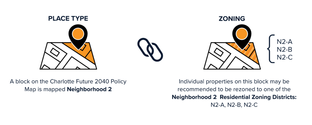
The Charlotte Future 2040 Policy Map will not change the zoning of your property. The Charlotte Future 2040 Policy Map will assign a Future Place Type designation to each property in the city’s jurisdiction.
There will be a separate process to align the Zoning Map with the 2040 Policy Map after the Unified Development Ordinance (UDO) is adopted by City Council. The Charlotte Future 2040 Policy Map will help inform the alignment rezoning process. Specifically, the zoning for each property will be assessed to determine if it is consistent with the property’s Place Type designation. Where the zoning of a property is not aligned with its Place Type, a zoning change for the property may be recommended.
The final recommendations to change the zoning district for a particular property will be dependent on existing conditions and context, location considerations (e.g., adjacencies to other Places or Zoning Districts, proximity to transit, frontage on a major arterial, access to an interchange), market readiness, and other temporal considerations (e.g., facilitating more gradual change over time).
No, the Charlotte Future 2040 Policy Map will not specify if residential units are for-rent or for-sale. The Charlotte Future 2040 Policy Map will indicate what type of development (including land use, building form, and mobility options) are appropriate for an area.
No, the Charlotte Future 2040 Policy Map will not specify if residential units are affordable.
No, the Charlotte Future 2040 Policy Map will not identify where a new grocery store will be constructed. The map does indicate where that type of development is appropriate. Commercial locations, such as grocery stores, are determined by a property owners and/or developer and based on market suitability which evaluates factors such as population within a certain radius and other grocery stores in the area.
No, residents will still be encouraged to participate in the rezoning process as required by state law.
The Charlotte Future 2040 Comprehensive Plan and Unified Development Ordinance are intended to create a better connection between the community’s vision and its regulatory tools to implement the vision as well as make future development more predictable and transparent for residents, property owners, and investors.
COMMUNITY AREA PLAN – FAQ
Community Area Plans provide detailed recommendations for land use, transportation, infrastructure, and community amenities within the city’s sub-geographies. Community Area Plans are an important component within Charlotte’s planning framework which ensures all planning efforts are aligned and aimed at implementing the vision of the Charlotte Future 2040 Comprehensive Plan.
Like Small Area Plans, Community Area Plans will protect and enhance Charlotte’s neighborhoods by providing detailed strategies for growth and development. Community Area Plans, however, provide a more coordinated and efficient planning structure by covering larger geographies than Small Area Plans. Benefits of the Community Area Planning approach include:
- Community-level guidance for the entire city
- Facilitation of conversations and collaboration among neighborhoods
- Assessment of major barriers that typically serve as neighborhood boundaries
- Efficient and effective structure for identifying citywide policy amendments
Charlotte’s Small Area Plans were retired upon adoption of the Charlotte Future 2040 Comprehensive Plan (June 2021) because the comprehensive plan provides both citywide and modernized guidance for development. However, Charlotte’s Small Area Plans, especially those completed within the last 10 years, will inform Community Area Plans by providing a starting point for the plans’ recommendations and priorities.
The Charlotte Future 2040 Comprehensive Plan defines the city’s comprehensive vision for growth over the next 20 years and establishes a planning framework to align and guide future planning efforts. Community Area Plans are the third tier within Charlotte’s planning framework and provide more detailed strategies for growth within the city’s sub-geographies. Once complete, Community Area Plans serve as a supplement to the comprehensive plan’s recommendations. They may also update the comprehensive plan’s companion map, the Charlotte Future 2040 Policy Map, and inform future updates or revisions.
Community Area Plans will be developed using a four-step planning process and include robust community engagement. Plans should be updated approximately every 10 years.
Community Area Plans build upon the vision and goals established in the Charlotte Future 2040 Comprehensive Plan by providing more detailed strategies and recommendations for land use, transportation, infrastructure, and community amenities. Community Area Plans will also include implementation strategies for prioritizing investments.
Community Area Planning will begin after the Unified Development Ordinance’s new development regulations are adopted and existing entitlements are translated to a new zoning districts. The Community Area Planning process will identify inconsistencies between adopted Place Type designations (per the Charlotte Future 2040 Policy Map) and new zoning designations. It will also recommend alignment of the two designations as a future implementation action. Adoption of the Community Area Plan will not change the zoning of a property.
The Community Area Plan boundaries were first drafted based on several considerations including expected population growth, development patterns, and natural boundaries. The boundaries were then refined to align with Neighborhood Profile Areas (NPAs) which are based upon federal reporting geographies used at all levels of government (local, state, and federal) to provide a consistent framework for reporting and comparing data.
The Community Area Plan boundaries will not be revised during the current planning process. The boundaries will be reviewed during the next Census and revised if needed to align with potential NPA adjustments.
The Community Area Plan boundaries were used throughout the Charlotte Future 2040 Comprehensive Plan and Policy Map planning efforts to 1) help organize and structure community discussions and 2) establish consistent data collection and reporting geographies. The boundaries will provide the same functionality in the Community Area Plan process and will not limit or restrict consideration of issues and opportunities that may exist within “areas of influence” or proximity to the plan boundaries.
[1] ‘Charlotte Future 2040 Comprehensive Plan Growth Factors Report’, www.cltfuture2040.com, April 2019, page 8-9, https://cltfuture2040.com/wp-content/uploads/2020/08/2019-04-17_Char_Growth-Factors_FINAL.pdf
[2] ‘Charlotte Future 2040 Comprehensive Plan Built City Equity Atlas, www.cltfuture2040.com, April 2019, page 48-74, https://cltfuture2040.com/wp-content/uploads/2020/08/2019-04_18_Char_Equity-Atlas_FINAL.pdf