2040 Policy Map FAQ
\n\n
 [/cs_content_seo][cs_element_accordion_item _id=”18″ ][cs_content_seo]2. Can the Unified Development Ordinance (UDO) districts be mapped without the Charlotte Future 2040 Policy Map?\n\nNo, the UDO cannot be implemented without the Charlotte Future 2040 Policy Map. A property’s Place Type designation is needed to determine many of the standards and requirements that will be found in the UDO and must be in place prior to the UDO taking effect. \n\n[/cs_content_seo][cs_element_accordion_item _id=”19″ ][cs_content_seo]3. Why is Charlotte using Place Types as a new classification system to organize development patterns? \n\nIn 2012, the CONNECT Our Future planning effort introduced the 14-county region to Place Types as a best-practice for guiding land development and ensuring future growth advances the region’s priorities. Place Types were used to help visualize and ultimately define the region’s preferred growth concept.
In 2015, the Charlotte Planning, Design & Development Department (CPDD) undertook an internal audit to evaluate what was or wasn’t working well with the area planning process. The audit revealed that 73% of the city had outdated policy guidance (adopted between 1990 – 2007) and new planning tools or procedures were needed to address the deficiency.
In 2016, CPDD explored whether Place Types, introduced by CONNECT Our Future, could provide a comparable level of guidance as had been developed in recent area plans. Research revealed Place Types 1) provided comprehensive guidance by addressing land use, building design, mobility, and open space and 2) could accelerate the area planning process and help provide updated policy guidance for the entire city.
In 2018, the Charlotte Planning, Design, and Development Department kicked-off the Charlotte Future 2040 Comprehensive Plan process. Place Types were included in the plan development process and ultimately adopted as a component of the Charlotte Future 2040 Comprehensive Plan.
Charlotte is not the only agency in the region using Place Types. Other regional partners have integrated Place Types into their planning processes:
In 2016, Place Types were used in the Metrolina CommunityViz Model 1.0 which informed the Charlotte Regional Transportation Planning Organization’s (CRTPO) 2045 Metropolitan Transportation Plan (MTP).
In 2020, Place Types were used again in the 2020 Metrolina CommunityViz Model 2.0 which informed the 2050 MTP and the CONNECT Beyond Regional Transit Study.
Furthermore, a number of local jurisdictions, such as the Town of Huntersville, have utilized Place Types to update their community’s master plans.
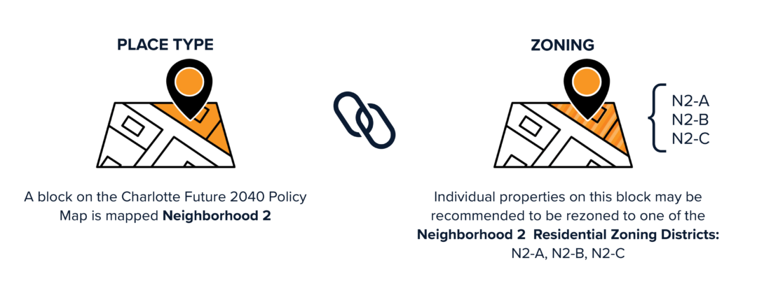
\n\n[/cs_content_seo][cs_element_accordion_item _id=”20″ ][cs_content_seo]4. Will the Charlotte Future 2040 Policy Map change the zoning of my property?\n\nThe Charlotte Future 2040 Policy Map will not change the zoning of your property. The Charlotte Future 2040 Policy Map will assign a Future Place Type designation to each property in the city’s jurisdiction.
There will be a separate process to align the Zoning Map with the 2040 Policy Map after the Unified Development Ordinance (UDO) is adopted by City Council. The Charlotte Future 2040 Policy Map will help inform the alignment rezoning process. Specifically, the zoning for each property will be assessed to determine if it is consistent with the property’s Place Type designation. Where the zoning of a property is not aligned with its Place Type, a zoning change for the property may be recommended.
The final recommendations to change the zoning district for a particular property will be dependent on existing conditions and context, location considerations (e.g., adjacencies to other Places or Zoning Districts, proximity to transit, frontage on a major arterial, access to an interchange), market readiness, and other temporal considerations (e.g., facilitating more gradual change over time).\n\n[/cs_content_seo][cs_element_accordion_item _id=”21″ ][cs_content_seo]5. Will the Charlotte Future 2040 Policy Map specify if residential units are for-rent or for-sale? \n\nNo, the Charlotte Future 2040 Policy Map will not specify if residential units are for-rent or for-sale. The Charlotte Future 2040 Policy Map will indicate what type of development (including land use, building form, and mobility options) are appropriate for an area.\n\n[/cs_content_seo][cs_element_accordion_item _id=”22″ ][cs_content_seo]6. Will the Charlotte Future 2040 Policy Map specify if residential units must be affordable? \n\nNo, the Charlotte Future 2040 Policy Map will not specify if residential units are affordable. \n\n[/cs_content_seo][cs_element_accordion_item _id=”23″ ][cs_content_seo]7. Will the Charlotte Future 2040 Policy Map identify where a new grocery will be constructed? \n\nNo, the Charlotte Future 2040 Policy Map will not identify where a new grocery store will be constructed. The map does indicate where that type of development is appropriate.
Commercial locations, such as grocery stores, are determined by a property owners and/or developer and based on market suitability which evaluates factors such as population within a certain radius and other grocery stores in the area.\n\n[/cs_content_seo][cs_element_accordion_item _id=”24″ ][cs_content_seo]8. Will the Charlotte Future 2040 Policy Map eliminate residents’ opportunity to participate in rezonings? \n\nNo, residents will still be encouraged to participate in the rezoning process as required by state law.
The Charlotte Future 2040 Comprehensive Plan and Unified Development Ordinance are intended to create a better connection between the community’s vision and its regulatory tools to implement the vision as well as make future development more predictable and transparent for residents, property owners, and investors. \n\n[/cs_content_seo][/cs_element_accordion][/cs_element_layout_column][/cs_element_layout_row][/cs_element_section][cs_element_section _id=”25″ ][cs_element_layout_row _id=”26″ ][cs_element_layout_column _id=”27″ ][cs_element_image _id=”28″ ][/cs_element_layout_column][cs_element_layout_column _id=”29″ ][cs_element_headline _id=”30″ ][cs_content_seo]Contact us:\n\n[/cs_content_seo][cs_element_text _id=”31″ ][cs_content_seo]Email: cltfuture2040@charlottenc.gov
Phone: 704.336.2205
Address: 600 E 4th St, Charlotte NC, 28202
\n\n[/cs_content_seo][cs_element_widget_area _id=”32″ ][/cs_element_layout_column][/cs_element_layout_row][/cs_element_section][/cs_content]